
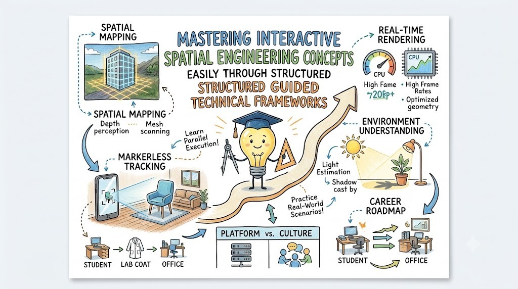
Augmented reality often feels like an intimidating domain reserved exclusively for specialized graphics engineers and mathematical experts. However, mastering immersive physical-digital overlays becomes remarkably straightforward when you have access to structured, hands-on tutorials. Aspiring developers can systematically break down these spatial computing mechanics through the comprehensive resources provided by debug.school. This specialized educational hub simplifies complex coordinate tracking, real-time spatial rendering, and camera anchor alignment into clear, actionable lessons. Consequently, engineers can rapidly build, test, and deploy interactive physical-digital experiences without feeling overwhelmed by low-level computer vision algorithms.
Key Operational Concepts You Must Know
Spatial Mapping Mechanics
Spatial mapping serves as the core foundation for placing digital content accurately within a real-world physical environment. Instead of relying on static flat screens, immersive devices scan surrounding surfaces to build a dynamic three-dimensional mesh representation. Consequently, this digital mesh enables virtual objects to interact naturally with physical tables, floors, and walls.
Furthermore, advanced spatial mapping platforms continuously refine surface boundaries as users move throughout their physical environment. This dynamic refinement ensures that depth occlusion works properly, allowing real physical objects to obscure virtual elements realistically.
Therefore, understanding mesh generation, surface estimation, and spatial persistence is essential for building believable digital overlays. When you master these core mechanics, anchoring persistent virtual objects across real locations feels entirely intuitive.
Markerless Motion Tracking
Tracking device motion across physical space without relying on printed paper markers represents a massive technological breakthrough. Markerless tracking engines analyze live camera feeds alongside inertial sensor data to calculate real-time device positioning. As a result, software applications track camera movement smoothly across six degrees of freedom.
Initially, early tracking software relied heavily on high-contrast visual features, which frequently failed on plain white walls. While those early systems worked reasonably well in controlled environments, they created frustrating tracking drops for everyday users.
Subsequently, modern motion tracking frameworks fused visual feature tracking with high-frequency accelerometer and gyroscope measurements. By combining visual feature points with hardware motion data, modern tracking frameworks maintain precise positioning even during rapid camera movements.
Real-Time Rendering Pipelines
Rendering digital content over live camera feeds introduces strict performance demands that traditional desktop graphics platforms rarely face. Spatial rendering engines must draw 3D models at exceptionally high frame rates to maintain perfect alignment with the real world. Any processing lag creates uncomfortable visual drift, breaking the immersive illusion and causing user motion discomfort.
Conversely, mobile devices operate under tight thermal limits and battery constraints, restricting available GPU computational power. Engineers must carefully optimize geometry counts, texture budgets, and shader complexity to maintain rock-solid performance.
Ultimately, successful spatial development requires a thoughtful balance between high visual quality and aggressive rendering optimization. This delicate balance guarantees smooth visual tracking while preserving precious battery life on handheld mobile devices.
Environmental Understanding and Lighting
Seamlessly blending synthetic graphics into physical space requires an application to analyze surrounding lighting conditions automatically. Environmental estimation algorithms analyze camera imagery to detect physical light direction, overall intensity, and ambient color temperature. Without this environmental awareness, bright virtual objects look completely out of place in dimly lit physical rooms.
Moreover, modern spatial engines project realistic soft shadows from virtual objects onto real-world floors and surfaces. These subtle environmental shadows anchor digital assets visually, convincing the human eye that virtual objects truly belong in the physical space.
As a result, mastering light estimation, shadow projection, and environmental reflection maps is vital for polished development. Proper environmental integration transforms basic floating 3D graphics into believable physical-digital interactions.
Platform Implementation vs. Culture — What's the Real Difference?
The Technology Trap in Engineering
Many development teams mistakenly believe that purchasing high-end hardware devices or adopting expensive spatial SDKs guarantees immediate project success. This narrow technical focus leads directly into a technology trap where teams implement complex platforms without establishing clear operational workflows. Consequently, organizations end up with fragile, unmaintainable spatial applications that struggle to perform reliably outside laboratory settings.
In reality, a platform serves merely as an underlying tool, rather than a complete strategy for complex spatial product design. When developers focus exclusively on platform features while ignoring core user experience principles, software quality deteriorates quickly.
Therefore, sustainable engineering requires prioritizing fundamental spatial principles over trendy hardware accessories or temporary platform tools. Mastering core concepts like camera tracking math, memory optimization, and intuitive user interactions prevents costly architectural redesigns later.
Fostering a Data-Driven Engineering Culture
A healthy spatial development culture emphasizes collaborative prototyping, rigorous real-world testing, and shared responsibility across multidisciplinary teams. In this progressive environment, teams treat spatial experiences as living products requiring continuous field testing across diverse physical environments. This cultural foundation ensures that applications remain robust across varying lighting conditions, room sizes, and physical layouts.
Additionally, a supportive engineering culture encourages developers to experiment safely, share technical bottlenecks openly, and learn from operational field failures. This open approach eliminates team friction and dramatically speeds up the development of intuitive spatial features.
When an organization successfully balances platform capabilities with a mature engineering mindset, software delivery improves significantly. Developers stop troubleshooting basic environment errors and start creating meaningful, reliable spatial tools that users love.
| Aspect | Platform Implementation | Culture & Mindset |
|---|---|---|
| Primary Focus | Installing software SDKs, configuring hardware headsets, and setting up rendering engines. | Standardizing interaction guidelines, testing across real environments, and continuous learning. |
| Longevity | Short-term focus that changes whenever new hardware or software libraries are released. | Long-term foundation that remains stable across changing hardware generations. |
| Success Metric | Frame rate stability, device compatibility, and feature deployment speed. | User intuition, tracking reliability across locations, and team collaboration efficiency. |
| Core Value | Delivers the raw rendering performance and tracking capabilities required for applications. | Establishes sustainable engineering quality standards and user-centered design practices. |
Real-World Use Cases of Modern Operations
Interactive Remote Field Maintenance
Industrial field technicians frequently encounter complex machinery that requires specialized expertise to repair safely and quickly. By wearing smart glasses or holding mobile devices, technicians view step-by-step repair instructions superimposed directly onto physical machinery. This spatial guidance highlights exact valves, bolts, and wire connections, drastically reducing human error during maintenance operations.
Simultaneously, offsite senior experts view the technician's live video feed and draw spatial annotations directly into their field of view. These virtual annotations remain pinned to physical machine components, providing crystal-clear visual guidance across vast geographic distances.
- Key Requirements: Ultra-low latency video streaming, precise spatial anchoring, and hands-free voice interaction options.
- Core Benefit: Minimizes costly factory downtime while reducing training expenses for field repair technicians.
- Data Scale: Streams high-definition camera feeds and real-time telemetry data across secure corporate networks.
Immersive Architectural Spatial Visualization
Architects and construction planners traditionally relied on flat blueprints and scale models to convey complex building designs to clients. Modern spatial visualization tools transform these static blueprints into full-scale 3D virtual building structures placed directly onto physical construction sites. Consequently, clients walk through full-scale virtual rooms, evaluating spatial layouts and material choices long before ground breaking occurs.
Furthermore, construction managers overlay digital BIM models directly onto ongoing physical construction to detect structural alignment errors early. Identifying misaligned piping or structural beams early prevents expensive rework and keeps massive commercial projects on schedule.
- Data Types: Dense 3D geometry meshes, architectural CAD models, and spatial environment scans.
- Operational Goal: Catch expensive design flaws early and streamline communication between architects, builders, and clients.
- Analysis Method: Aligns heavy architectural 3D models with real-world physical coordinate frames on active job sites.
Spatial E-Commerce and Retail Previews
Online retail shoppers often hesitate to purchase furniture and home decor due to uncertainty about sizing, color matching, and physical placement. Spatial e-commerce applications solve this hesitation by allowing customers to preview true-to-scale digital furniture inside their actual living rooms. Users easily rotate, reposition, and inspect prospective purchases from any camera angle before checking out.
Meanwhile, background analytics systems capture user interaction patterns, tracking which furniture pieces are tested most frequently in physical homes. These valuable insights inform inventory purchasing decisions and help retailers refine product designs based on real user behavior.
- Target Outcomes: Higher sales conversion rates, reduced product return rates, and enhanced customer satisfaction.
- Pipeline Structure: Light weight 3D model streaming pipelines integrated seamlessly into existing mobile shopping applications.
- Scale Challenge: Rendering photorealistic product textures across hundreds of different mobile device hardware configurations.
Common Mistakes in Operations Engineering
Over-Engineering Simple Visual Experiences
A common mistake among new developers is building overly complex custom spatial engines when standard lightweight tools work perfectly fine. Driven by technical curiosity, teams often implement custom tracking libraries or low-level graphics pipelines for basic visualization tasks. This unnecessary complexity introduces tricky memory leaks, unexpected device crashes, and massive maintenance burdens for the development team.
Consequently, project delivery stalls because developers spend more energy troubleshooting custom low-level engine code than refining product features. Simplicity and stability should always remain top priorities when designing interactive spatial software.
Therefore, you should leverage established open-source libraries and proven platform tools whenever starting a new spatial software project. Keeping your tech stack simple ensures fast iteration cycles, lower maintenance overhead, and higher overall software stability.
Neglecting Environmental Variance in Field Testing
Developing spatial applications exclusively inside well-lit, controlled office environments almost guarantees unexpected failure when deployed to real-world users. Dark rooms, reflective glass surfaces, and featureless floor tiles easily confuse computer vision algorithms, causing severe tracking loss. Without thorough field testing across diverse real-world environments, applications become unreliable and frustrating for end users.
To prevent these embarrassing field failures, engineering teams must implement automated quality testing protocols across varying light levels and surface textures. Testing applications on low-end target hardware in cluttered physical spaces exposes hidden performance bottlenecks early.
Ultimately, building robust spatial software requires accepting that physical environments are unpredictable, messy, and constantly changing. Designing defensive fallback modes ensures your application degrades gracefully whenever spatial tracking fails unexpectedly.
Ignoring Performance Optimization and Battery Thermal Limits
It is surprisingly easy to overheat mobile devices and drain battery life by rendering unoptimized 3D assets at high frame rates. Inexperienced developers frequently import massive, uncompressed high-poly models designed for desktop consoles directly into mobile spatial applications. These heavy assets overload mobile GPUs, causing sudden frame drops, thermal throttling, and immediate app crashes.
Moreover, failing to implement proper object culling and texture compression techniques wastes valuable hardware processing capacity unnecessarily. Unoptimized code severely degrades user experience and quickly drains mobile battery reserves in just a few minutes of use.
As a result, developers must prioritize poly-count reduction, texture atlasing, and strict draw-call budgeting throughout the development cycle. Writing resource-conscious rendering code guarantees smooth frame rates and keeps mobile devices running cool during extended usage sessions.
How to Become an Operations Expert — Career Roadmap
Step 1: Mastering Fundamentals
Begin your learning path by establishing a rock-solid foundation in core mathematics, 3D linear algebra, and software development practices. Focus heavily on understanding vector operations, matrix transformations, quaternions, and 3D coordinate system manipulations. Additionally, gain proficiency in primary programming languages such as C# or C++ while mastering basic object-oriented design principles.
- Core Focus: Master linear algebra concepts, learn standard 3D coordinate transformations, and practice core C# or C++ programming.
- Learning Resources: Interactive math tutorials, fundamental graphics programming books, and structured developer documentation.
- Estimated Time: Spend your initial months mastering these essential mathematical building blocks before downloading heavy gaming engines.
Step 2: Understanding Distributed Core
Once you feel confident with basic 3D mathematics, transition into learning standard spatial engine workflows and component-based architectures. Study how game engines organize scenes, handle physics collisions, manage lighting systems, and execute render loops efficiently. Practice building basic interactive 3D desktop applications to understand frame timing and input handling.
- Core Focus: Learn scene graph structures, master component lifecycle events, and implement basic 3D physics interactions.
- Practical Projects: Build a small desktop 3D application that spawns, moves, and manipulates 3D objects using user input controls.
- Key Concept: Focus on understanding how modern graphics engines process scene data and pass rendering commands to hardware GPUs.
Step 3: Mastering Advanced Frameworks
Advance your skill set by integrating mobile spatial tracking SDKs and specialized computer vision libraries into your projects. Learn how to handle plane detection events, manage spatial anchors, process hit testing rays, and implement real-time occlusion. Additionally, master performance profiling tools to identify rendering bottlenecks, draw call spikes, and memory leaks.
- Core Focus: Implement markerless tracking pipelines, manage persistent world anchors, and optimize rendering shaders for mobile GPUs.
- Design Skills: Design intuitive spatial user interfaces that sit naturally inside 3D environments without cluttering the user field of view.
- Optimization Goal: Eliminate frame drops and reduce memory overhead to maintain smooth performance across mobile hardware.
Step 4: Enterprise Orchestration and Cloud Deployment
Finalize your transformation into a senior developer by learning how to connect local spatial applications with cloud-based spatial services. Master remote asset streaming, multi-user real-time state synchronization, and cloud-assisted persistent anchor management systems. Finally, learn how to automate build pipelines, manage cross-platform deployments, and secure enterprise data flows.
- Core Focus: Deploy cloud spatial anchors, set up multi-user shared experiences, and automate continuous integration build pipelines.
- Career Growth: Transition from a basic software developer into a lead spatial systems architect capable of directing enterprise projects.
- Final Goal: Build scalable, cross-platform spatial applications that synchronize complex 3D state seamlessly across distributed global users.
FAQ Section
- What programming languages are most useful for spatial development? C# and C++ serve as the dominant programming languages for spatial interactive software development. C# is widely used within primary game engines, while C++ is essential for low-level graphics and computer vision development.
- How does markerless tracking detect physical surfaces without targets? Markerless tracking uses feature point detection combined with device motion sensors to locate physical surfaces automatically. The software identifies high-contrast visual points across consecutive camera frames to calculate floor and wall planes.
- Why do mobile devices overheat quickly during spatial app usage? Spatial applications run the camera feed, computer vision tracking algorithms, and a 3D graphics rendering engine simultaneously. This intensive multi-system processing heavily taxes both CPU and GPU, producing heat and consuming battery quickly.
- Can I start learning spatial engineering without expensive headset hardware? Yes, you can easily master core spatial engineering principles using a standard modern smartphone. Handheld mobile devices support advanced spatial tracking SDKs, making them ideal low-cost tools for learning spatial development concepts.
- Why is frame rate stability so critical in spatial applications? Frame rate stability prevents visual latency jitter between head movement and digital rendering update cycles. Stable, high frame rates keep virtual objects glued in place, preventing visual drift and avoiding user motion discomfort.
Final Summary
Mastering interactive spatial engineering does not require a complex mathematical background, but it demands a disciplined learning path grounded in fundamental spatial principles. By breaking down camera tracking, spatial mapping, and mobile rendering into manageable milestones, developers can build impressive immersive applications confidently. Structured learning platforms like debug.school offer guided technical tutorials, practical exercises, and career roadmaps that make navigating spatial computing straightforward. Avoid getting distracted by temporary platform hype; focus your energy instead on mastering linear algebra, rendering optimization, and real-world environmental testing. Ultimately, combining strong software fundamentals with a collaborative development culture empowers you to create magical, reliable spatial experiences that seamlessly bridge the physical and digital worlds.



Top comments (0)